Environmental surveying is a complex and essential field that involves using advanced surveying techniques to determine the potential impacts of construction projects. There are many different types of environmental surveys, one of the most important of which is a hydrographic survey.
Hydrographic surveys play a critical role in mapping underwater terrain, allowing ships and other maritime vessels to navigate these waterways safely. These types of surveys may also be required for compliance purposes.
If you own a business that operates in or relies on maritime vessels, it’s essential to familiarize yourself with hydrographic surveying, how it works, and what benefits it provides.
Fortunately, there’s no need to waste hours skimming the results of a search query like “What is a hydrographic survey?” You can find everything you need to know about hydrographic surveys in this convenient guide.
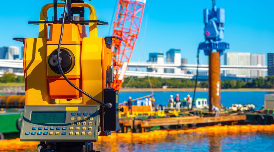
We put together this primer to help you understand how hydrographic surveys work and what hydrographic survey instruments technicians will use to analyze your land. Let’s dive in.
Table of Contents
What Is Hydrographic Surveying?
Hydrographic surveying measures underwater features, such as submerged obstructions that may impact activities like marine construction, maritime navigation, offshore oil drilling, and similar ventures. This type of survey is performed by a certified hydrographic survey technician or, more likely, a team of them.
Hydrographic surveys reveal insights about potential underwater obstructions and provide information about tides, currents, and the seabed itself. They’re performed using various scientific instruments, and the most common are echo-sounding devices or sounding lines deployed from ships.
However, modern hydrographic surveying techniques have also begun incorporating advanced electronic sensors and aircraft. These techniques are primarily used to survey shallower waterways, so researchers don’t risk damaging their ships.
Hydrographic surveys eliminate unpleasant surprises during drilling, exploration, or construction projects. Without them, construction teams may encounter potentially dangerous conditions that could put them at risk or compromise the project’s viability.
And as you’ll soon learn, hydrographic surveys are critical when developing and sticking to a workable project budget.
Why Do We Need Hydrographic Surveys?
Hydrographic surveys provide detailed insights into underwater terrain. Without the information they offer, construction teams would be working in the dark, forced to carefully and tediously navigate uncharted waterways to ensure they don’t accidentally collide with hidden obstructions.
Hydrographic surveys enable maritime exploration and construction businesses to protect costly equipment and, more importantly, their crews. Even a seemingly minor collision could be incredibly dangerous when it occurs in uncharted waterways or involves a submersible vessel.
Hydrographic surveying also makes it possible for maritime vehicles and equipment to traverse the water without the risk of hitting underwater terrain and promotes movement efficiency.
Project leaders can use survey mapping data to chart routes well in advance. Once they begin navigating waterways, they can do so confidently, using the findings as their guide.
This efficiency benefit can significantly decrease a project timetable. And by increasing operational efficiency and drastically reducing the likelihood of equipment damage, project leaders can decrease overall project costs.
Hydrographic surveys are an essential service that must be performed during the planning phase of any maritime exploration or construction project. Without them, these projects would be prohibitively expensive and procedurally difficult to the point of near futility.
How Does a Hydrographic Survey Work?
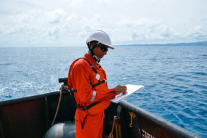
Hydrographic survey technicians can perform a survey in one of several ways. The specific methodology they use will largely depend on the nature of the project.
Their key responsibility is to gather enough data so that project leaders can construct nautical charts. Some specific details that surveyors must provide include water depth variations across the surveyed area and any obstructions’ location and size.
When planning the hydrographic survey, the technician will work with business leaders to determine the project’s scope. They’ll discuss everything from the project’s underlying purpose to the specifics of its timetable and budget.
After defining these variables, the hydrographic survey technician will select the most appropriate surveying method based on the client’s needs. Factors that influence which process the surveyor selects include budget, delivery deadline, and the size of the area to be surveyed.
Hydrographic survey data is used for an assortment of purposes, including:
- Planning the construction of docks
- Identifying underwater channels
- Planning and building dams
- Reclaiming land
- Guiding oil drilling and exploration efforts
These are just a few use cases; generally speaking, hydrographic surveys are critical for planning virtually any water-related construction or exploration project.
What Are the Methods of Hydrographic Surveying?
As mentioned, there are many different hydrographic survey methods. The earliest method of hydrographic surveying was known as line-and-pole surveying.
When conducting a line-and-pole survey, technicians would lower a weighted cable to the bottom of the seafloor to gauge the depth at a particular site. They would repeat this process dozens of times in nearby areas, gradually getting an idea of the depth of the intended exploration, excavation, or building zone.
Line-and-pole surveying was both inaccurate and time-consuming, and it was easy for water currents to cause the weighted cable to drift slightly, thereby skewing depth data. Fortunately, this method has been replaced with more accurate and efficient technologies like side scan sonar, LiDAR, GPS, and acoustic Doppler current profiles.
Side Scan Sonar
Side scan sonar technology enables surveyors to scan expansive areas of terrain in a single pass. It’s primarily used to detect potentially dangerous obstructions and terrain. However, it can also be employed in conjunction with other technologies to gain additional insights into the contours and features of a patch of seabed terrain.
LiDAR
Light detection and ranging (LiDAR) technology emits light pulses to scan a seabed. This laser-powered technology can provide highly detailed imaging of seabed terrain.
LiDAR is typically used to survey areas ahead of dredging and guide the placement of underwater pipelines and similar components.
GPS
GPS technology can precisely determine the exact position of a sounding boat and scanning equipment, ensuring that surveyors analyze the correct areas and avoid accidentally drifting outside the designated survey zone.
Acoustic Doppler Current Profile
Acoustic Doppler current profile (ADCP) technology uses a phenomenon known as the Doppler effect to study discharge effects on rivers, canals, and other waterways. ADCP technology emits sound waves at varying angles, allowing surveyors to understand water flow in a particular waterway better.
What Is Sounding in Hydrographic Surveys?
All of the above technologies are used to perform various types of “sounding,” which is the modern method for conducting hydrographic surveys. While the specific scope of sounding can vary, all forms of this technique use sound waves to gather data about seabed terrain and locate potential obstructions.
Sounding determines the distance between the water’s surface and the seabed, a measurement more commonly referred to as water depth.
Since sea level fluctuates during low and high tides, surveyors must first determine the mean (average) sea level before they can begin sounding. Doing so helps them generate more relevant data and, in turn, create accurate oceanic charts.
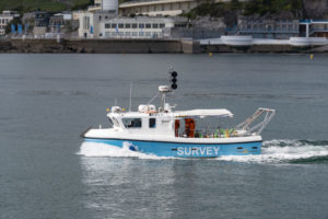
The vessels that perform this technique are known as sounding boats. They follow predetermined paths called sounding lines during each phase of the survey. Vessels track their progress along the sounding lines using GPS technology. Buoys may also be deployed to guide vessels as they perform soundings.
Sounding can be performed by several different types of marine vessels, including:
- Inflatable boats
- Unmanned underwater vehicles (UUVs)
- Autonomous underwater vehicles (AUVs)
Often, these vessels will attach the sounding devices to the stern or rear of the vehicle. This approach protects the equipment from damage in the event of a collision. However, there are some instances when it’s strategically preferable to attach sounding equipment to the front of a vessel.
What Is the Difference Between Hydrographic and Bathymetric Surveys?
As mentioned, you can use hydrographic surveys to determine various details about the seabed and overall ocean depth. But there are multiple types of hydrographic surveys, each of which is intended to reveal a specific piece of information about the waterway being examined.
Perhaps the most well-known type of hydrographic survey is the bathymetric survey. Bathymetric surveys are designed to ascertain the depth of a specific body of water. The word “bathymetric” is derived from the Greek phrase “bathus,” meaning “depth,” and the term “metric” comes from “metron,” meaning measurement.
A bathymetric survey is, therefore, a hydrographic survey, but the opposite is not necessarily true. Other types of hydrographic surveys include:
- Wreck location surveys
- Dredging analysis
- Waterway planning
- Runoff tracing
Hydrographic surveys are crucial for planning and constructing dams, harbors, docks, and other water-related structures.
When conducting surveys for these projects, technicians perform a bathymetric analysis and several other scans. Cumulatively, this data will guide project planners’ construction efforts so they can safely and efficiently complete their build.
Choosing a Hydrographic Survey Service
Hydrographic surveys are central in planning water-related construction projects, avoiding maritime accidents, reclaiming land, and protecting construction crews. It’s, therefore, critical that you make them a part of your project planning process.
Failing to do so could drastically increase the costs of your project, endanger workers, and threaten the viability of your undertaking.
With that in mind, you must choose the right hydrographic survey service for your company’s needs. You must select a service provider that’s knowledgeable, fully licensed, and capable of operating within your given timetable to ensure you avoid encountering any unexpected and costly delays.
That’s why you need to partner with an experienced hydrographic survey partner like Alpha-Omega Training and Compliance, Inc. (AOTC), a veteran-owned and operated company based in Titusville, FL.
Our dynamic team of experienced surveyors and technicians provides an extensive range of water-related engineering services. We routinely partner with municipalities, federal government entities, industrial organizations, and commercial businesses to see their projects through to completion.
AOTC and our hydrographic surveying services can help you overcome many challenges when taking on a water-related construction project. We address concerns such as:
- Sustainable water management
- Erosion
- Flooding
- Water treatment
- Water reclamation
When tackling your hydrographic survey or water-related engineering project, we’ll apply our years of in-the-field expertise to devise a unique solution that aligns with your company’s needs and goals.
We work efficiently using the latest technology to ensure your reports are prepared promptly so you can move forward with your project. We can even accommodate condensed delivery timetables for fast-moving projects of particular importance.
Schedule a consultation with AOTC today to learn more about our water-related engineering and hydrographic survey services and begin laying the groundwork for your next project. As an employee-owned company, client satisfaction and safety are always our top priorities.